Flooding: Risk Assessment Flood Tool (RAFT)
Buoy your flood planning with RAFT
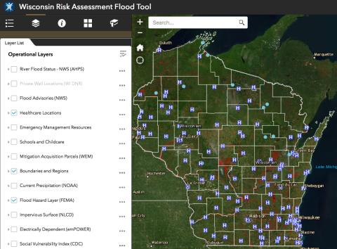
Floods create a wide range of public health and safety risks, and they can be deadly and costly. In response to more frequent and intense floods in Wisconsin, the Department of Health Services and partners created the Risk Assessment Flood Tool (RAFT) map to help local, regional, and state agencies prepare for and respond to floods. RAFT to the rescue!
Formerly called the Wisconsin Flood Risk Map Application, RAFT integrates 35 flood-relevant spatial data layers in one customizable ArcGIS map.
Features include:
- 35 data layers from 13 state and federal agencies.
- FEMA flood hazard layer view in relation to health care locations.
- Social vulnerability data by census tract.
- LIVE precipitation data, 72-hour precipitation forecast, flood advisory feeds, and river flood level status.
- And more!
Access RAFT and learn more
- Map: Risk Assessment Flood Tool
- Data detail: 35 data layers
- Training options: tutorial or webinar
RAFT users
Get ready for the next flood with RAFT. Whether you work in emergency management, public health, or natural resources, RAFT was designed with you in mind:
- Emergency management and preparedness professionals
- First responders or public safety professionals
- Public health preparedness and planning professionals
- Health care planners
- Flood plain managers
- Water resources, waste water operators and land use planners
- Zoning administrators
- Environment, stormwater, and infrastructure professionals
Help us improve RAFT
Are there other data layers you would like to see in RAFT? Do you have ideas on how we can improve the map tool?
We want to hear from you! Please share your feedback in our short, two-minute survey.


